Mark Poynting and Matt McGrathBBC News Climate and Science
 Kevin Carter/Getty Images
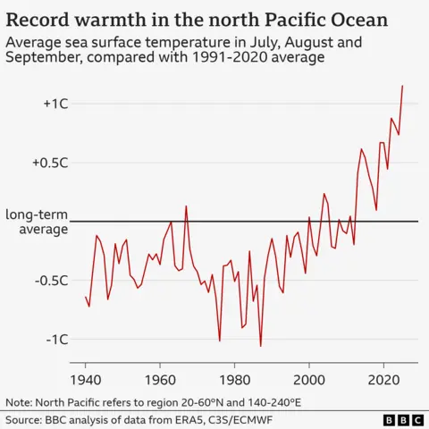
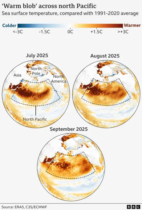
The waters of the north Pacific have had their warmest summer on record, according to BBC analysis of a mysterious marine heatwave that has confounded climate scientists.
Sea surface temperatures between July and September were more than 0.25C above the previous high of 2022 – a big increase across an area roughly ten times the size of the Mediterranean.
While climate change is known to make marine heatwaves more likely, scientists are struggling to explain why the north Pacific has been so hot for so long.
But all this extra heat in the so-called “warm blob” may have the opposite effect in the UK, possibly making a colder start to winter more likely, some researchers believe.
“There’s definitely something unusual going on in the north Pacific,” said Zeke Hausfather, a climate scientist at Berkeley Earth, a research group in the US.
Such a jump in temperatures across a region so large is “quite remarkable”, he added.
The BBC analysed data from the European Copernicus climate service to calculate average temperatures between July and September across a large area of the north Pacific, sometimes known as the “warm blob”.
The region extends from the east coast of Asia to the west coast of North America, the same area used in previous scientific studies.
The figures show that not only has the region been warming quickly over the past couple of decades, but 2025 is markedly higher than recent years too.

That the seas are getting hotter is no surprise. Global warming, caused by humanity’s emissions of carbon dioxide and other gases, has already trebled the number of days of extreme heat in oceans globally, according to research published earlier this year.
But temperatures have been even higher than most climate models – computer simulations taking into account humanity’s carbon emissions – had predicted.
Analysis of these models by the Berkeley Earth group suggests that sea temperatures observed across the north Pacific in August had less than a 1% chance of occurring in any single year.
Natural weather variability is thought to be part of the reason. This summer has seen weaker-than-usual winds, for example. That means more heat from the summer sunshine can stay in the sea surface, rather than being mixed with cooler waters below.
But this can only go so far in explaining the exceptional conditions, according to Dr Hausfather.
“It certainly is not just natural variability,” he said. “There’s something else going on here as well.”

One intriguing idea is that a recent change to shipping fuels might be contributing to the warming. Prior to 2020, dirty engine oil produced large amounts of sulphur dioxide, a gas harmful to human health.
But that sulphur also formed tiny, Sun-reflecting particles in the atmosphere, known as aerosols, which helped to keep a lid on rising temperatures.
So removing that cooling effect in shipping hotspots like the north Pacific could be revealing the full impact of human-caused warming.
“It does seem like sulphur is the primary candidate for what’s driving this warming in the region,” said Dr Hausfather.
Other research suggests that efforts to reduce air pollution in Chinese cities has played a role in warming the Pacific too.
That dirty air did a similar job to shipping in reflecting sunlight away, while cleaning it up could have had the unintended consequence of allowing more ocean heating.
Possible impacts for the UK?
The north Pacific’s marine heatwave has already had consequences for weather on both sides of the Pacific, likely boosting very high summer temperatures in Japan and South Korea and storms in the US.
“In California, we’ve seen supercharged thunderstorms because the warm ocean waters in the Pacific provide heat and moisture,” said Amanda Maycock, professor in climate dynamics at the University of Leeds.
“In particular, there are things we call atmospheric rivers… bands of air, which contain very high amounts of moisture that fuel themselves from the ocean waters,” she added.
“So if we have warm ocean waters… they can then bring a lot of moisture onto the land, which then falls out as rain, or in the wintertime can precipitate out as snow.”
 Reuters
Long-term weather forecasting is always challenging, but extreme heat in the north Pacific has the potential to affect the UK and Europe in the coming months too.
That’s because of relationships between weather in different parts of the world known as teleconnections.
“Although the current warm conditions are located in the north Pacific, these can generate wave motions in the atmosphere that can alter our weather downstream into the north Atlantic and into Europe,” said Prof Maycock.
“That can tend to favour high-pressure conditions over the continent, which brings us more of an influence from the Arctic, where we have colder air,” she added.
“That can be drawn over Europe and bring us colder weather in early winter.”
A colder outcome is by no means certain, as this is a complex area of science. Several other weather patterns also affect UK winters, which are typically getting milder with climate change.
And a warm north Pacific appears to have different effects later in the winter, favouring milder and wetter conditions in some parts of Europe.
Emerging La Niña in the tropical Pacific
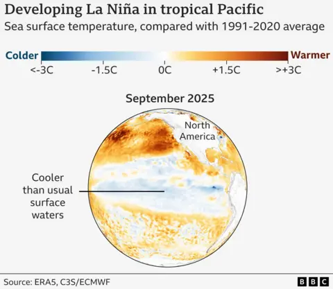
Another factor to throw into the mix is what’s happening further south in the eastern tropical Pacific.
There, surface waters are unusually cool – a classic sign of the weather phenomenon known as La Niña.

La Niña, and its warm sibling El Niño, are natural patterns, although research published this week highlighted that global warming could itself impact the swings between them.
Weak La Niña conditions are expected to persist over the next few months, according to NOAA, the US science agency.
All else being equal, La Niña generally increases the risk of a cold start to winter in the UK, but also brings a higher chance of a mild end, the Met Office says.
“These two drivers in the north and tropical Pacific will be acting together this winter,” said Prof Maycock.
“But since the La Niña is quite weak this year, the extreme warmth in the north Pacific could be more important for forecasting the winter ahead.”
Additional reporting by Muskeen Liddar and Libby Rogers


